

Heart of Wales Line Trail Passport
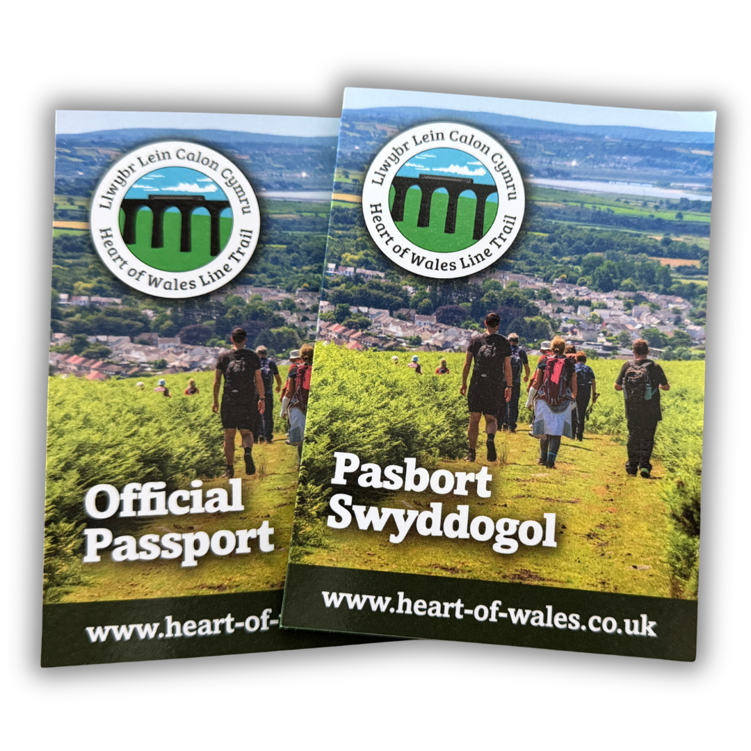
The Heart of Wales Line Trail Passport is a record of your journey and can be used whether you walk the trail in one go or do sections over time. This passport scheme has been developed and is managed by the charity ‘Friends of the Heart of Wales Line Trail’ and all proceeds go towards the upkeep of the trail.
The ’Friends’ developed the passport in order to enhance the experience of walking this wonderful trail whilst supporting small business along the way. They also wish to encourage even more walkers to seek out this railway-inspired long-distance path and all the variety it offers.
Collecting Stamps
There are currently 16 towns and villages where you can get your passport stamped along the trail. All ‘Stamping Stops’ are based within local businesses that have signed up to support the scheme. You will find all the locations on the map below. Please click the link of each location to find out their opening times.
There are 10 MAIN locations which have at least two Stamping Stops, hopefully this means you can collect stamps whatever time you arrive.
There are also 6 ADDITIONAL (bonus) locations which, mostly, only have one Stamping Stop, therefore you may not be able to collect stamps if opening hours are not compatible with your arrival time.
The emphasis of the passport is not necessarily on collecting ALL the stamps but on using the passport to enhance your walking adventure along the trail.
However, if you collect 10 or more stamps you can apply for a free trail gift and certificate. Please e-mail heartwalestrail@gmail.com with your name as you would like it to appear on your certificate, an image of your passport and your address.
Stamping Stops
ADDITIONAL STAMPING STOPS MARKED WITH #
- Shropshire Hills Discovery Centre SY7 9RS, Craven Arms, Shropshire, England, United Kingdom
- # Aston on Clun Community Shop Broome Road, Aston on Clun, Lydbury North, SY7 8EH, United Kingdom
- # The Kangaroo Inn Clun Road, Aston on Clun, Lydbury North, SY7 8EW, United Kingdom
- # The Sitwell Arms Old Bedstone Road, Bucknell, SY7 0DE, United Kingdom
- The Banc Knighton 5 Broad Street, Knighton, LD7 1BL, United Kingdom
- Prince & Pugh 24 Broad Street, Knighton, LD7 1BS, United Kingdom
- # The Thomas Shop LD1 5UA, Llandrindod Wells, Powys, Wales, United Kingdom
- Lakeside Boathouse Princes Avenue, Llandrindod Wells, LD1 5HU, United Kingdom
- The Llanerch Inn Llanerch Lane, Llandrindod Wells, LD1 6BH, United Kingdom
- # Newbridge on Wye Post Office and Convenience Store LD1 6LH, Llandrindod Wells, Powys, Wales, United Kingdom
- The Fountain Inn 7-9 Broad Street, Builth Wells, LD2 3DT, United Kingdom
- The Strand Cafe 2 Groe Street, Builth Wells, LD2 3DW, United Kingdom
- Neuadd Arms Hotel LD5 4RB, Llanwrtyd Wells, Powys, Wales, United Kingdom
- Llanwrtyd & District Heritage & Arts Centre 3 Ffoss Road, Llanwrtyd Wells, LD5 4RG, United Kingdom
- The Castle Hotel King's Road, Llandovery, SA20 0AW, United Kingdom
- Books at the Dragon's Garden 9 High Street, Llandovery, SA20 0PU, United Kingdom
- Bumblebees of Llandovery 6 Market Square, Llandovery, SA20 0AA, United Kingdom
- Morgan Newsagents & Post Office Church Street, Llangadog, SA19 9AA, United Kingdom
- Y Castell SA19 9BW, Llangadog, Carmarthenshire, Wales, United Kingdom
- # Myddfai Community Hall & Visitor Centre SA20 0JD, Llandovery, Carmarthenshire, Wales, United Kingdom
- Diod 135 Rhosmaen Street, Llandeilo, SA19 6EN, United Kingdom
- Cegin Diod SA19 6BJ, Llandeilo, Carmarthenshire, Wales, United Kingdom
- Yr Hen Vic 82 New Road, Llandeilo, SA19 6DF, United Kingdom
- # Coaltown Coffee Foundry Road, Ammanford, SA18 2LS, United Kingdom
- Canolfan Y Bont 28 Dulais Road, Pontarddulais, Swansea, SA4 8PA, United Kingdom
- Black Horse Inn 161 Iscoed Road, Fforest, Swansea, SA4 0UN, United Kingdom
- Llanelli Wetland Centre SA14 9SH, Llanelli, Carmarthenshire, Wales, United Kingdom
- Llanelli Railway Goods Shed Trust Marsh Street, Llanelli, SA15 1AU, United Kingdom
- Pentre Awel Leisure Centre SA15 2DR, Llanelli, Carmarthenshire, Wales, United Kingdom
Frequently Asked Questions
What if Stamping Stops are closed?
At the 10 MAIN LOCATIONS there should be at least two Stamping Stops so check to make sure if there is an alternative that might be open.
At the 6 ADDITIONAL LOCATIONS, which are the smaller villages, it is more likely that the Stamping Stops will have limited open hours, so it is a bonus if you can catch one that is open.
If you don’t manage to get a stamp, don’t worry. You only need to get 10 in total to claim your free gift and completion certificate.
If a Stamping Stop is closed when it is advertised as open, please let us know and we’ll ask them to update their information.
Why aren’t there Stamping Stops in every town or village along the trail?
Not every location has a suitable place for a Stamping Stop, many villages are so small and remote they don’t even have a shop.
If you have suggestions for future Stamping Stops please let us know.
Is there an expiry date on the passport?
No. You can keep your passport for years and collect stamps at your own pace.
How can I buy a passport?
The passport is currently only for sale on the website. Follow the link on this page to buy one. In future we will look at physical places that you can buy them too. If you prefer to pay by cheque please send an email to heartwalestrail@gmail.com
What is the free gift?
The free gift is currently a sew-on patch for the trail. In future the free gift may change.
How do I claim the free gift and certificate?
When you have 10 stamps or more on your passport and would like to claim a free gift and certificate, please photograph it and send it to heartwalestrail@gmail.com along with your name and address.
How can I get a passport sent to me outside of the UK?
If you live outside of the UK and would like to order a passport please e-mail heartwalestrail@gmail with your name and address and we can calculate the cost of postage and send you a payment link.
THANK YOU TO OUR SPONSORS AND SUPPORTERS